Navonics for Android

Classic Parker Boat Forum

Help Support Classic Parker Boat Forum:

This site may earn a commission from merchant affiliate links, including eBay, Amazon, and others.

mcyc

Well-known member
Joined
Feb 3, 2010
Messages
123
Reaction score
0
Location
Point PLeasant NJ
Has anyone used this app...I figured its 15 bucks may be worth it if just for a backup....Im going out tomm night i let you know what i think.
 
I love my Navionics charts - where can you get charts at that price?
screenshot_1.png


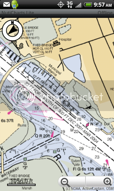
Oh wait! How about free NOAA charts online from NutiCharts Lite? You can buy a smaller area than Navionics for less money if you want to use them offline.
ScreenShot-6.png

Search Android market for 'nutiteq'
 
I have the Navionics charts on my iPhone, but I think it was more than $15.
 
I have the Navionics charts on my "Commando" from Casio
I love it used it twice this year on my friends boat fishing
Works great got it off the Apps store on Verizon
It was 14.99
 
I would love to have this as a back up .. But does it work if you don't service? we fish 50 to 60 miles off service is gone around 55 miles out . not sure about gps servie.. Hope yall can shed me alttle light on this.
 
Resident maps will work for both without phone service, and if your phone is equipped with a real gps chip you will be fine there too even without phone service.
 
I'm using both the apps jeffnick mentioned on a Samsung Galaxy Tab and so far no complaints.
 
Megabyte":1y5eyvfl said:
I have the Navionics charts on my iPhone, but I think it was more than $15.

Kevin i was just reading about this app on my Iphone is it worth getting? They lowered the price to 9.99. Just looking for some feed back to see if its worth it or not.
 
miky2884":18vnsic2 said:
Megabyte":18vnsic2 said:
I have the Navionics charts on my iPhone, but I think it was more than $15.

Kevin i was just reading about this app on my Iphone is it worth getting? They lowered the price to 9.99. Just looking for some feed back to see if its worth it or not.

To be honest, it is not my primary so I don't use it much.
I bought it as a backup to the Garmin 2010 on my boat and to use as a secondary while on deliveries, but I do think it is worth the money.
The best part is that it is a one time purchase. Updates are always free.

I keep all of my boating apps in a folder, and the one that I use the most is called "RadarScope".
You might want to take a look at that one too.
 
miky2884":3qvwqex1 said:
does it show your track line, and show you moving over the water?

Yes. Track is an option at the bottom of the screen. You can turn it on and off at will.
 
jeffnick":w0la3ir9 said:
Resident maps will work for both without phone service, and if your phone is equipped with a real gps chip you will be fine there too even without phone service.
does the iPhone 4 have this?
 
Parker23":vmzpvx5t said:
jeffnick":vmzpvx5t said:
Resident maps will work for both without phone service, and if your phone is equipped with a real gps chip you will be fine there too even without phone service.
does the iPhone 4 have this?

If you are asking if the iPhone 4 has a GPS chip, the answer is yes.

Had to go over to BOE Marine to pick up an anchor light I had ordered, and decided to fiddle with the Navonics app en-route.
Discovered that if the phone is plugged in, it does not go to sleep like other apps will.
I liked that!
 
I messed with it last night, From what I saw it worked well...Didn't fiddle with it too much because we got on top of a nice bunker boil filled with bass.
 
I just bought it, for my iPhone. Looks pretty cool so far.
 
I also down loaded it fo rmy iphone4 looks pretty good, gonna try it out tonight on the boat.
 
For whats its worth, My family and I were out on the forth, about 45 miles from port and my GPS on my Raymarine unit stopped working. I found water in the antenna and couldnt get power to it. At the time it went out we were across the chesapeake and needed to come across the bay into pax river and then about 20 miles up the river in the dark, no moon, and no GPS. My wife freaked out and said I know you can get us back, but with no GPS in the dark? At that point I grapped my android phone downloaded this app, and throttled up......made it back in no time, and it worked great!! put her mind at ease, and now I can use it as a backup. Better yet the wife said, why dont you get a second unit on the boat!!! great I get the ok to buy somthing else!!
 
I started with the Navionics apps and expanded from there as you'll see below. :lol:

I have a refurbed Sprint Galaxy Tab and mobile mount with a $20 data plan. I used Navionics Central on a recent trip to Door County, WI recently and found it spot on. It got me wading distance to the beach on Rock Island which my I couldn't do with my chartplotter. I downloaded apps for tides, anchor alarm, marine weather and weather radar, gas prices and Nuticharts Lite for marina info from Active Captain. The only thing missing is an app overlaying current on the charts. In the truck, I use it with GasBuddy, CoPilot Live for navigation, Boat Ramps for finding ramps and Trip Advisor for racks and eats. This thing has really become my boating/travel go to device, but I also run OffShore Navigator on the boat as back up. It's also great for email and browsing the web, tho I'd subscribe to VPN service before using open wifi networks.

My only complaint about the Navionics apps is I wish they'd display charts in landscape mode and course up.
 
Back
Top